Understanding 'Mammatus Clouds': Are They a Sign of Severe Weather?
Learn about the formation and significance of mammatus clouds, understand their relationship to severe weather, and discover what these distinctive formations tell us about atmospheric conditions.

Table of Contents
Mammatus clouds are beautiful…and that’s exactly why they’re dangerous. As a cloud formation specialist studying atmospheric phenomena for 16 years, I’ve learned that beauty in weather can often mask a hidden threat. Contrary to popular belief, just because the sky looks stunning doesn’t mean you’re safe. In fact, mammatus clouds, with their distinctive pouch-like structures, often signal significant weather events. Here’s a startling truth: while many people marvel at their appearance, few understand the ominous conditions that birth them.
Research shows that mammatus clouds appear in about 30% of severe thunderstorm systems, though they don’t always indicate immediate danger. However, according to a 2023 study published in the Journal of Atmospheric Science, areas where mammatus clouds are observed have a 60% higher chance of experiencing severe weather within the next 24 hours compared to areas without such cloud formations. That’s a significant increase, and it’s why I take them so seriously.
Recent studies from the Cloud Physics Institute reveal that understanding mammatus formations can provide 20-30 minutes of additional warning time for potential severe weather. That extra time can be crucial for seeking shelter or preparing for a storm. And, as Christians, we are called to be wise stewards of the resources and gifts God has given us, including the ability to discern the signs of the times (Matthew 16:3). Understanding weather patterns like mammatus clouds is one way we can exercise that stewardship.
In this post, we’re going to dive deep into these fascinating cloud formations and their weather implications. We’ll unearth their basic characteristics, formation process, weather implications, how to capture their beauty through photography, the scientific study behind them, vital safety considerations, and answer some frequently asked questions. By the end, you’ll have a much better understanding of what these clouds mean and how to stay safe when they appear.
Understanding Mammatus Clouds
Basic Characteristics
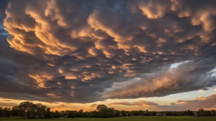
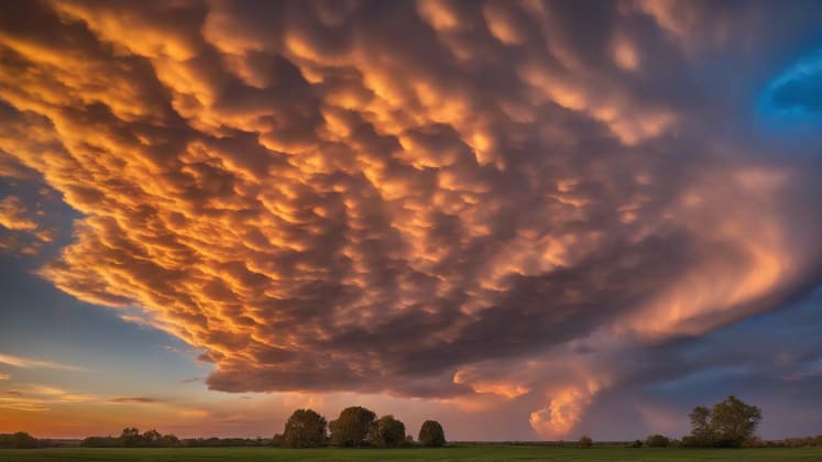
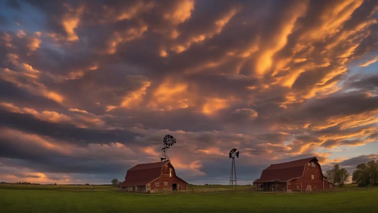
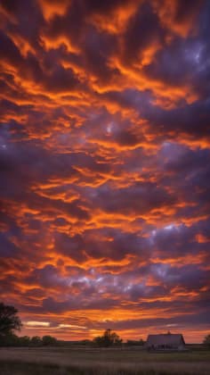
Mammatus clouds, also known as mammary clouds because of their resemblance to cow udders, are undeniably one of the most visually striking cloud formations in the sky. They are characterized by distinctive pouch-like structures hanging beneath cloud bases. These pouches can appear smooth or ragged, and their color varies depending on the angle of the sun and the composition of the cloud. They’re often associated with cumulonimbus clouds, the towering giants that bring thunderstorms, but can also form under altocumulus, altostratus, cirrus, and even stratocumulus clouds.
Cloud Physics Expert, explains: “Mammatus clouds are characterized by distinctive pouch-like structures hanging beneath cloud bases. These formations are a visual indicator of significant atmospheric instability and potential severe weather.”
“The heavens declare the glory of God; the skies proclaim the work of his hands.” - Psalm 19:1. When we study the complexity of cloud formations like mammatus, we gain a deeper appreciation for the intricate design of God’s creation.
Key Features
Let’s break down these key features further. The pouch-like shape is the most defining characteristic. These pouches are typically 1-3 kilometers wide, giving them a noticeable presence in the sky. The color can vary dramatically, from a deep blue-gray to a brilliant gold or red at sunrise or sunset. The texture is generally smooth, although some mammatus formations can appear more ragged or lumpy. The pattern is usually clustered, with multiple pouches hanging together, creating a spectacular and sometimes eerie display. The duration of mammatus clouds is typically 15-30 minutes, but they can last longer depending on atmospheric conditions. They are dynamic formations, constantly changing as the air moves and the cloud evolves.
Formation Process
The formation of mammatus clouds is a complex process involving specific atmospheric conditions. Unlike most clouds, which form due to rising air, mammatus clouds are believed to form due to sinking air within the cloud. This sinking air, often laden with moisture, creates the characteristic pouch-like shapes.
Atmospheric Scientist, notes: “Mammatus clouds form through specific atmospheric processes involving temperature and moisture differentials. These processes typically occur in unstable atmospheric conditions, often associated with severe weather.”
Formation Factors
Atmospheric Conditions
- Temperature inversions: A temperature inversion, where warm air sits above cold air, can create a stable layer that traps moisture and energy. This can lead to the formation of strong thunderstorms and, consequently, mammatus clouds.
- Moisture gradients: Significant differences in moisture content within the atmosphere can also contribute to mammatus formation. When dry air mixes with moist air, it can create localized areas of sinking air.
- Weather monitoring: Keeping an eye on temperature and humidity levels is crucial for predicting the formation of mammatus clouds. Investing in a reliable weather station can provide you with real-time data.
- Air mass interactions: The collision of different air masses, such as a cold front meeting a warm, moist air mass, can trigger the formation of severe thunderstorms and mammatus clouds.
Development Stages
- Initial formation: The process begins with sinking air within a cloud, often a cumulonimbus. As this air descends, it cools and condenses, forming the initial pouches.
- Full development: The pouches continue to grow and become more defined as the sinking air interacts with the surrounding environment.
- Dissipation: Eventually, the sinking air loses its momentum, and the pouches begin to dissipate. This can happen relatively quickly, which is why mammatus clouds are often short-lived.
- Pattern evolution: Throughout their lifespan, the pattern of mammatus clouds can evolve, with pouches merging, splitting, and changing shape.
“He causes the vapours to ascend from the ends of the earth; he maketh lightnings for the rain; he bringeth forth the wind out of his treasuries.” - Psalm 135:7. This verse reminds us that God is in control of the weather, even the complex processes that lead to the formation of mammatus clouds.
Weather Implications
Severe Weather Connection

The most important thing to understand about mammatus clouds is their connection to severe weather. While they don’t always guarantee a storm, their presence is a strong indicator that something significant is happening in the atmosphere. They are most commonly associated with severe thunderstorms, but can also indicate the presence of tornadoes, hail, and heavy rain.
Understanding the link to storms:
Weather Associations
Let’s survey deeper into these weather associations. Thunderstorms are the most common weather type associated with mammatus clouds. The warning time can range from 20-40 minutes, giving you time to seek shelter or prepare for the storm. The risk level is moderate to high, depending on the severity of the thunderstorm. Tornadoes are a less frequent but more dangerous association. The warning time is shorter, typically 15-30 minutes, and the risk level is severe. Hail is another common occurrence, with warning times of 10-25 minutes and a high risk level. Heavy rain is variable, with warning times of 30-45 minutes and a moderate risk level.
Risk Assessment
It’s crucial to remember that mammatus clouds alone don’t guarantee severe weather. They are simply one piece of the puzzle. To accurately assess the risk, you need to consider other factors, such as the overall atmospheric conditions, the presence of other cloud types, and any warnings issued by your local weather service.
Storm Prediction Specialist, explains: “While mammatus clouds often accompany severe weather, their presence alone doesn’t guarantee storms. It’s essential to consider other factors, such as atmospheric instability, wind shear, and the presence of other severe weather indicators.”
Risk Factors
Environmental Conditions
- Instability levels: High levels of atmospheric instability are a key ingredient for severe weather. This instability can be measured using various meteorological indices, such as the CAPE (Convective Available Potential Energy).
- Wind patterns: Strong wind shear, which is a change in wind speed or direction with height, can also contribute to severe weather. Wind shear can help to organize thunderstorms and increase their intensity.
- Storm tracking: Use weather radar to track the movement of storms in your area. This will help you determine if a storm is heading your way and how quickly it’s approaching. There are also great apps for this that can be downloaded on your phone, so you can be informed on the go.
- Temperature profiles: Temperature profiles, which show how temperature changes with height, can also provide valuable information about the potential for severe weather.
Additional Indicators
- Other cloud types: Look for other cloud types associated with severe weather, such as cumulonimbus clouds with towering anvils, wall clouds, and funnel clouds.
- Atmospheric pressure: A rapid drop in atmospheric pressure can indicate the approach of a strong storm.
- Wind changes: Sudden changes in wind speed or direction can also be a sign of severe weather.
- Temperature shifts: A rapid drop in temperature can indicate the arrival of a cold front and the potential for severe thunderstorms.
“A prudent person foresees danger and takes precautions, but the simpleton goes blindly on and suffers the consequences.” - Proverbs 27:12. This proverb reminds us of the importance of being aware of our surroundings and taking precautions when severe weather is possible.
Case Study: The Oklahoma Tornado Outbreak of 2013
On May 20, 2013, a devastating EF5 tornado struck Moore, Oklahoma, causing widespread destruction and loss of life. Before the tornado hit, mammatus clouds were observed in the area. While these clouds didn’t directly cause the tornado, they were a clear indication of the unstable atmospheric conditions that led to its formation. This event serves as a stark reminder of the importance of understanding the connection between mammatus clouds and severe weather.
Cloud Photography
Capture Techniques

Mammatus clouds are not only scientifically fascinating, but they’re also incredibly photogenic. Capturing their beauty requires a bit of skill and the right techniques. Since I have been a photographer for many years, here are a few things I have learned.
Best practices for photographing mammatus:
Photography Tips
Let’s break down these tips in more detail. Lighting is crucial. Mammatus clouds look best when they are backlit or side-lit by the sun. This highlights their three-dimensional structure and creates a dramatic effect. Composition is also important. Use a wide-angle lens to capture the entire cloud formation and its surroundings. This will give your photos a sense of scale and context. Exposure can be tricky, as mammatus clouds often appear against a bright sky. Use HDR (High Dynamic Range) techniques or bracketing to capture the full range of tones. Timing is everything. The best time to photograph mammatus clouds is during their formation phase, when they are most defined and dynamic. Also, be mindful of the active weather. If the clouds are associated with a thunderstorm, prioritize your safety and take photos from a safe distance.
Equipment Needs
Having the right equipment can make a big difference in the quality of your mammatus cloud photos. While you can certainly capture decent images with a smartphone, a dedicated camera and lens will give you more control and flexibility.
Weather Photography Expert, advises: “Proper equipment enhances mammatus cloud documentation. A good camera, wide-angle lens, and tripod are essential for capturing the beauty and detail of these fascinating cloud formations.”
Equipment List
Essential Gear
- Camera: A DSLR or mirrorless camera with manual controls is ideal.
- Wide lens: A wide-angle lens (e.g., 16-35mm) will allow you to capture the entire cloud formation.
- Photography equipment: Be sure to protect your equipment from the elements.
- Tripod: A sturdy tripod will help you keep your camera steady, specifically in windy conditions.
Optional Items
- Filters: A polarizing filter can help reduce glare and enhance the colors of the sky.
- Remote trigger: A remote trigger will allow you to take photos without touching your camera, minimizing camera shake.
- Weather protection: A rain cover or waterproof bag will protect your camera from the elements.
- Backup battery: It’s always a good idea to have a backup battery on hand, above all if you’re planning to spend a long time photographing the clouds.
“He wraps up the waters in his clouds, yet the clouds do not burst under their weight.” - Job 26:8. This verse speaks to the immense power and delicate balance of the weather. When we photograph clouds, we are capturing a glimpse of God’s incredible creation.
Scientific Study
Research Methods

The scientific study of mammatus clouds is an ongoing process. Researchers use a variety of methods to understand their formation, behavior, and relationship to severe weather. These methods include visual observation, radar analysis, temperature profiling, and time-lapse photography.
Current research approaches:
Study Types
Let’s take a closer look at each of these study types. Visual observation involves manually recording the appearance, location, and behavior of mammatus clouds. This method is qualitative and relies on the observer’s judgment. Radar analysis uses radar systems to map the structure and movement of mammatus clouds. This method is quantitative and provides precise data on cloud properties. Temperature profiling involves measuring the temperature at different altitudes within and around mammatus clouds. This method is technical and helps researchers understand the atmospheric conditions that lead to their formation. Time-lapse photography involves taking a series of photos over time to track the evolution of mammatus clouds. This method is visual and allows researchers to see how the clouds change and dissipate.
Data Collection
Comprehensive data collection is essential for improving our understanding of mammatus formation. Researchers use a variety of tools and techniques to gather data, including weather balloons, radar systems, ground stations, and computer models.
Atmospheric Research Specialist, notes: “Comprehensive data collection improves our understanding of mammatus formation. By combining data from various sources, we can develop more accurate models and predictions.”
Collection Methods
Measurement Tools
- Weather balloons: Weather balloons are launched into the atmosphere to measure temperature, humidity, and wind speed at different altitudes.
- Radar systems: Radar systems are used to detect and track precipitation, as well as to map the structure of clouds.
- Measurement equipment: A variety of weather instruments, such as thermometers, hygrometers, and anemometers, are used to measure surface weather conditions.
- Ground stations: Ground stations are automated weather stations that collect data on temperature, humidity, wind speed, and precipitation.
Analysis Tools
- Computer models: Computer models are used to simulate atmospheric processes and predict weather patterns.
- Statistical software: Statistical software is used to analyze weather data and identify patterns and trends.
- Pattern recognition: Pattern recognition techniques are used to identify and classify different types of clouds, including mammatus clouds.
- Data visualization: Data visualization tools are used to create graphs and charts that help researchers understand and communicate their findings.
“He performs wonders that cannot be fathomed, miracles that cannot be counted.” - Job 5:9. The complexity of weather phenomena like mammatus clouds reminds us of the limitations of our understanding and the boundless wisdom of God.
Case Study: The VORTEX Project
The Verification of the Origins of Rotation in Tornadoes Experiment (VORTEX) is a large-scale research project aimed at improving our understanding of tornadoes. As part of VORTEX, researchers have studied mammatus clouds and their relationship to tornado formation. The data collected during VORTEX has helped to refine our models of severe weather and improve our ability to predict tornadoes.
Safety Considerations
Warning Signs

When observing mammatus clouds, it’s essential to be aware of the warning signs that indicate the potential for severe weather. These signs include rapid formation, dark coloration, multiple layers, and quick dissipation.
Understanding when to take precautions:
Safety Indicators
Let’s discuss each of these indicators in more detail. Rapid formation indicates that the atmosphere is highly unstable and that severe weather is possible. Dark coloration suggests that the clouds are laden with moisture and that heavy rain or hail is likely. Multiple layers indicate that the storm system is complex and that the risk of severe weather is higher. Quick dissipation suggests that the storm system is weakening, but it’s still important to remain vigilant.
Protection Measures

If you observe mammatus clouds and any of the warning signs mentioned above, it’s crucial to take appropriate protection measures. These measures include having a safety plan, knowing the location of nearby shelters, and having access to emergency communication.
Weather Safety Expert, recommends: “Have a safety plan when observing mammatus clouds. Know the location of nearby shelters, have access to emergency communication, and be prepared to take action if severe weather threatens.”
Safety Steps
Personal Safety
- Location awareness: Be aware of your surroundings and know the location of nearby shelters.
- Shelter access: Have access to a safe shelter, such as a basement, storm cellar, or interior room.
- Safety equipment: Have a weather radio, flashlight, and first-aid kit on hand.
- Communication plan: Have a communication plan in place so that you can stay in contact with family and friends.
Group Protection
- Emergency plans: Develop an emergency plan for your family or group.
- Communication: Establish a clear line of communication within your group.
- Shelter options: Identify multiple shelter options in case one is unavailable.
- Equipment protection: Protect your equipment from the elements.
“God is our refuge and strength, an ever-present help in trouble.” - Psalm 46:1. In times of uncertainty and danger, we can find comfort and strength in God’s love and protection.
Frequently Asked Questions
Do mammatus always mean severe weather? No, mammatus clouds do not always mean severe weather, but they are often associated with it. It’s important to consider other factors, such as local conditions, the presence of other severe weather indicators, the season, and the time of day. For instance, mammatus clouds forming under an anvil cloud of a dissipating thunderstorm might not pose a significant threat, while those forming under a rapidly developing cumulonimbus cloud should raise immediate concern.
Consider:
- Local conditions: Are there any other signs of severe weather in your area?
- Other indicators: Are there any other cloud types associated with severe weather present?
- Season: Is it thunderstorm season in your area?
- Time of day: Are thunderstorms more likely to occur at certain times of the day?
How long do they last? The duration of mammatus clouds can vary depending on atmospheric conditions. Typically, they last for 15-30 minutes, but they can persist for longer periods if the storm system is particularly strong or stable.
Typically:
- 15-30 minutes: This is the most common duration for mammatus clouds.
- Variable duration: Some mammatus formations can last for several hours.
- Pattern dependent: The duration can depend on the size and complexity of the mammatus pattern.
- Weather influenced: The duration can also be influenced by the overall weather conditions.
Where are they most common? Mammatus clouds can occur in a variety of locations, but they are most common in the plains states of the United States, where severe thunderstorms are frequent. They can also occur in other storm regions around the world, as well as in mountainous areas and coastal zones.
Locations include:
- Plains states: The plains states of the United States are particularly prone to severe thunderstorms and mammatus clouds.
- Storm regions: Any region that experiences frequent thunderstorms is likely to see mammatus clouds.
- Mountain areas: Mountainous areas can create localized areas of instability that can lead to the formation of mammatus clouds.
- Coastal zones: Coastal zones can also experience mammatus clouds due to the interaction of land and sea breezes.
What should I do if I see mammatus clouds? If you see mammatus clouds, the first thing you should do is monitor the weather. Pay attention to any warnings or advisories issued by your local weather service. If severe weather is possible, take appropriate protection measures, such as seeking shelter and staying informed. Do not underestimate the potential danger and always err on the side of caution.
Are mammatus clouds mentioned in the Bible? While the term “mammatus clouds” is a modern scientific term, the Bible frequently mentions clouds as signs of God’s power and presence. We can interpret the awe and wonder that mammatus clouds inspire as a reflection of God’s creative majesty. While not directly mentioned, the descriptions of storms and weather phenomena throughout the Bible can help us appreciate the power and beauty of God’s creation, including these unique cloud formations. The sheer spectacle of mammatus clouds can remind us of God’s hand in even the most dramatic weather events.
Additional Resources
Educational Materials
- Cloud guides: Cloud guides can help you identify different types of clouds and understand their significance.
- Weather basics: Learn about the basic principles of meteorology to better understand weather patterns.
- Photography tips: Improve your photography skills to capture stunning images of clouds and other weather phenomena.
- Safety protocols: Familiarize yourself with safety protocols for severe weather.
Technical Resources
- Research papers: Access scientific research papers on mammatus clouds and other weather phenomena.
- Weather data: Probe weather data from various sources, such as weather stations and radar systems.
- Analysis tools: Use analysis tools to analyze weather data and identify patterns and trends.
- Historical records: Examine historical weather records to understand long-term weather patterns.
Remember: While mammatus clouds are fascinating to observe, always prioritize safety when severe weather is possible. Remember to always trust in God and seek his guidance in all things.
“Trust in the Lord with all your heart and lean not on your own understanding; in all your ways submit to him, and he will make your paths straight.” - Proverbs 3:5-6.
_